


City marche La Ciotat

Spinnaker
User
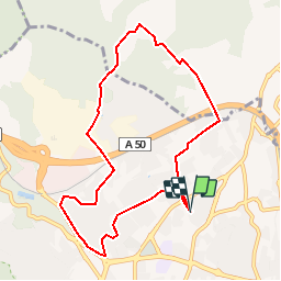

Length
9.4 km

Max alt
225 m

Uphill gradient
236 m
Km-Effort
12.5 km

Min alt
28 m

Downhill gradient
236 m
Boucle
Yes
Creation date :
2019-01-15 20:43:04.931
Updated on :
2019-01-15 20:43:04.931
2h00
Difficulty : Very easy

FREE GPS app for hiking
 SityTrail
IGN / Geographical institutes
SityTrail Plus
The world is yours!
About
Trail Other activity of 9.4 km to be discovered at Provence-Alpes-Côte d'Azur, Bouches-du-Rhône, La Ciotat. This trail is proposed by Spinnaker.
Positioning
Country:
France
Region :
Provence-Alpes-Côte d'Azur
Department/Province :
Bouches-du-Rhône
Municipality :
La Ciotat
Location:
Unknown
Start:(Dec)
Start:(UTM)
712690 ; 4786107 (31T) N.
Comments